Shanghai metro map
You can find on this page the Shanghai metro map to print and to download in PDF. The Shanghai metro map presents the network, zones, stations and different lines of the metro of Shanghai in China.
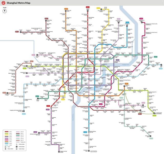
Metro map Shanghai
The Shanghai metro map shows all the stations and lines of the Shanghai metro. This metro map of Shanghai will allow you to easily plan your routes in the metro of Shanghai in China. The Shanghai metro map is downloadable in PDF, printable and free.
The Shanghai Metro rapid-transit system and elevated light rail has ten lines as its mentioned in Metro map Shanghai(numbers 1, 2, 3, 4, 5, 6, 7, 8, 9 and 11) at present and extends to every core urban district as well as neighbouring suburban districts such as Songjiang and Minhang. The Shanghai Metro system is one of the fastest growing metro systems in the world. Many lines are under construction or planned to be constructed in the near future. Four companies operate the Shanghai Metro network. Each of them are subdivisions of Shanghai Shentong Metro Group Co.,Ltd.
Shanghai subway map
The Shanghai subway map shows all the stations and lines of the Shanghai subway. This subway map of Shanghai will allow you to easily plan your routes in the subway of Shanghai en China. The Shanghai subway map is downloadable in PDF, printable and free.
The Shanghai Metro, incorporates both subway and light railway lines and extends to every core urban district as well as neighboring suburban districts as its mentioned in Shanghai subway map. As of 2010, there are twelve subway lines (including the Shanghai Maglev Train), 273 stations and over 420 km of tracks in operation, making it the longest subway network in the world. On 22 October 2010, Shanghai subway system set a record of daily ridership of 7.548 million. The fare depends on the length of travel distance starting from 3 RMB.